


peylanou

vincente204
User
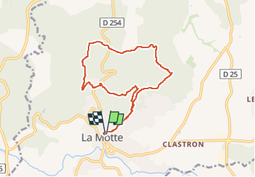

Length
8.6 km

Max alt
249 m

Uphill gradient
273 m
Km-Effort
12.2 km

Min alt
84 m

Downhill gradient
273 m
Boucle
Yes
Creation date :
2025-02-26 12:57:00.975
Updated on :
2025-02-26 15:31:12.036
2h33
Difficulty : Difficult

FREE GPS app for hiking
 SityTrail
IGN / Geographical institutes
SityTrail Plus
The world is yours!
About
Trail Walking of 8.6 km to be discovered at Provence-Alpes-Côte d'Azur, Var, La Motte. This trail is proposed by vincente204.
Description
facile
Positioning
Country:
France
Region :
Provence-Alpes-Côte d'Azur
Department/Province :
Var
Municipality :
La Motte
Location:
Unknown
Start:(Dec)
Start:(UTM)
300771 ; 4818642 (32T) N.
Comments